Main Street (Briggate)
On this page we travel up Briggate from the bottom near Church Lane to the top known as Town End.
Briggate, today known as Main Street, lies at the heart of the town dividing West Garforth from Church Garforth. Once mainly residential with a few small shops it has changed over time into a busy shopping street and is the centre of the modern community.
Architecturally Main Street is now very mixed with many old buildings surviving amongst less appealing 1960s brutalist concrete and more recent redevelopment. Many old details are obscured by gaudy modern shop fronts so as always it is for interested persons to try and see through to the history beyond.
Old Shops
We begin here with a collection of old shops which were all situated on Briggate over the years. I love old shop photos from the days when people took a lot of pride in their businesses and the proprietors can often been seen posing outside.


- date
- Unknown
- copyright
- Unknown
- resolution
- 489x589px · 163.0K ·
Burras Peake men’s wear shop. Pictured is Harold Bramley with manager Jack Haswell [3].
Burras Peake were a Leeds based menswear company with a factory on Gelderd Road and shops in various locations such as Garforth, Otley and Pontefract as well as the City centre.


- date
- 1950s
- copyright
- Unknown
- resolution
- 770x464px · 211.0K ·
Mr. Starkey’s cobbler’s shop in Main Street during the 1950s. This building was demolished and Mr. Starkey moved his business to the end of Barley Hill Road [3].
I can remember the shop that Mr. Starkey had on Barley Hill Road from when I was small as my Mum used to take her shoes in there to be mended. Mr. Starkey was an older man by that point and I remember he had a very slow and monotone way of speaking! He must have been in his business for an awfully long time as I don’t think that shop closed until c.1995.

- date
- c.1904
- copyright
- Unknown
- resolution
- 2000x1248px · 1.2M
- postcard
- Unknown NN05
This Liberal Club was in a similar location to the more modern Liberal Club which was transformed into The Briggate Wetherspoons around 2018.
This club looks to have been inside what would have once been a house and the location is also marked on some of the old OS maps.
Lower Briggate - General Stores and Post Office
TB Smith’s General Store on the left and the Post Office (hidden by an awning)
- date
- c.1909
- copyright
- Phototype Co.
- resolution
- 2000x1244px · 1.3M ·
- postcard
- Phototype 1878

- date
- …
- copyright
- …
- resolution
- … · …
The old Post Office
- date
- c.1925
- copyright
- Hoult
- resolution
- 2000x1231px · 1.1M
- postcard
- Hoult NN01

- date
- …
- copyright
- …
- resolution
- … · …

The old Council Offices which stood where T.B. Smith’s General Store once stood [3].
The cage on the roof of the building held the air raid siren from the war which I can remember being there in the 80s when I was small.
- date
- 1990s or early 21st century
- copyright
- Unknown
- resolution
- 782x487px · 221.2K

- date
- 5th August 2007
- copyright
- Ian Atkinson
- resolution
- 2000x1208px · 1.4M

Lower Briggate - Holly House and Alfred Smith Grocers
- date
- c.1907
- copyright
- Bramley
- resolution
- 2000x1246px · 1.7M ·
- postcard
- Bramley B07

- date
- 13th April 2020
- copyright
- Ian Atkinson
- resolution
- 2000x1237px · 1.4M


- date
- c.1905
- copyright
- Parkinson and Roy
- resolution
- 2000x1287px · 1.6M
- postcard
- Parkinson and Roy NN03
Looking up Briggate with Holly House in the centre left of the frame along with the end of Barley Hill Road.
The pale building on the far side of Barley Hill road was Preston’s tailors shop. Later on this unit was Knowles’ greengrocers and Everett’s the butcher’s [3]. This unit is now La Bella Vita Italian restaurant.


- date
- c.1967
- copyright
- The Francis Frith Collection
- resolution
- 2000x1270px · 2.7M ·
- postcard
- Frith GFH40

- date
- 13th April 2020
- copyright
- Ian Atkinson
- resolution
- 2000x1409px · 1.7M

Opposite the end of Barley Hill Road looking down towards Lidgett Lane.
In the centre right of the frame is Alfred Smith’s grocery shop and the attached living quarters known as Holly House (‘China Town’ in the contemporary image). Holly House later became the Leeds and Holbeck Building Society.
Alfred Smith’s shop was later owned by a Mrs Holliday and then the Shaws [3].
- date
- Unknown
- copyright
- Parkinson and Roy
- resolution
- 781x497px · 292.7K ·
- postcard
- Parkinson and Roy NN14

- date
- 25th August 2007
- copyright
- Ian Atkinson
- resolution
- 2000x1241px · 1.3M


- date
- c.1900–1910
- copyright
- Unknown
- resolution
- 1651x1023px · 829.9K ·
Holly House with the edge of Barley Hill Road just visible in the centre right of the frame. The house in the left of the frame no longer exists and newer shops have been re-built in its place.
The little girl in the picture is Flo ‘Flo Toes’ James who in later life was a teacher at the Parochial School and also starred in local theatre [3].
Lower Briggate - Sweet Shop Parade
- date
- Unknown
- copyright
- Parkinson and Roy
- resolution
- 2000x1264px · 1.3M ·
- postcard
- Parkinson and Roy 559

- date
- 13th April 2020
- copyright
- Ian Atkinson
- resolution
- 2000x1261px · 1.4M

Looking towards Lidgett Lane, this image shows Holly House and the end of Barley Hill Road in the centre of the frame.
In the right of the frame is a parade of shops comprising of H. Appleyard, P. Breckon’s sweet shop and and Louis Dimler’s pork butcher’s [3].
- date
- c.1909
- copyright
- Phototype Co.
- resolution
- 1297x811px · 448.4K ·
- postcard
- Phototype 1873

- date
- 13th April 2020
- copyright
- Ian Atkinson
- resolution
- 2000x1253px · 1.4M

Briggate Centre
- date
- c.1967
- copyright
- The Francis Frith Collection
- resolution
- 2000x1306px · 2.4M ·
- postcard
- Frith GFH44

- date
- 19th April 2019
- copyright
- Ian Atkinson
- resolution
- 2000x1314px · 1.6M

- date
- c.1967
- copyright
- The Francis Frith Collection
- resolution
- 2000x1266px · 2.5M ·
- postcard
- Frith GFH46

- date
- 19th April 2019
- copyright
- Ian Atkinson
- resolution
- 2000x1310px · 1.5M

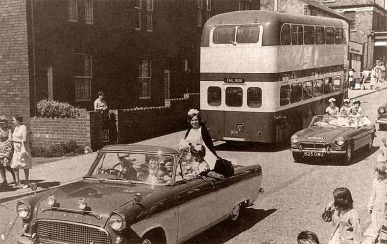
The middle of Main Street with the top of Coupland Road in the right of the frame.
It is possible that this particular photograph is of a procession carrying the cross from St. Joseph’s to the newly built St. Benedict’s in Aberford Road [3].
- date
- Possibly 1960s
- copyright
- Unknown
- resolution
- 782x476px · 247.6K

- date
- 27th August 2007
- copyright
- Ian Atkinson
- resolution
- 2000x1228px · 1.2M

- date
- Unknown
- copyright
- Unknown
- resolution
- 787x464px · 204.4K ·

- date
- 27th August 2007
- copyright
- Ian Atkinson
- resolution
- 2000x1295px · 1.5M

Eagle House can be seen in the right of the frame in this image of Armistice Day celebrations.
- date
- 1918
- copyright
- Unknown
- resolution
- 1490x919px · 700.1K ·

- date
- 27th August 2007
- copyright
- Ian Atkinson
- resolution
- 2000x1252px · 1.5M

The right hand side of Main Steet with the Welfare Hall in the centre left of the frame.
The houses shown, ‘Colliery Row’ and ‘Long Curtain Row’, were replaced by a parade of shops.
It was here that Jack Charlton, the footballer once ran his men’s wear business [3].
- date
- Unknown
- copyright
- Unknown
- resolution
- 783x498px · 237.5K ·

- date
- 27th August 2007
- copyright
- Ian Atkinson
- resolution
- 2000x1257px · 1.5M


- date
- unknown
- copyright
- H Burniston
- resolution
- 2000x1247px · 1.1M
- postcard
- H Burniston 137
The miners' welfare hall which was built in 1924.

- date
- c.1908
- copyright
- Bramley
- resolution
- 2000x1228px · 1.3M ·
- postcard
- Bramley B06
Looking towards Town End from the middle of Main Street. The houses on the right were demolished in the 1950s, but the large house beyond them, Eagle House, still stands today at the end of Chapel Lane [2].


- date
- Unknown
- copyright
- Parkinson and Roy
- resolution
- 2000x1257px · 1.4M ·
- postcard
- Parkinson and Roy NN09


Coupland Road and Marshall’s
The end of Providence Cottages can be seen on the left. There is then a gap where Bellevue Cottages would later be built and the next house along is Newport House opposite the Salvation Army Citadel on the right.
The closest row of houses on the right were knocked down to make the entrace to Halliday Road.
- date
- c.1907
- copyright
- Parkinson and Roy
- resolution
- 2000x1270px · 1.4M ·
- postcard
- Parkinson and Roy 560

- date
- May 2016
- copyright
- resolution
- 2000x1267px · 655.2K


- date
- Unknown
- copyright
- Laycocks
- resolution
- 2000x1211px · 1.0M
- postcard
- Laycocks 1051
This image is taken slightly further forward than Parkinson and Roy 560 and we can now see Bellevue Cottages have been built on the left.

- date
- c.1937
- copyright
- Milton
- resolution
- 2000x1286px · 1.2M ·
- postcard
- Milton NN05
This is the furthest forward of the three Coupland Road images with the Salvation Army Citdael now more clearly visible on the right and Newport House on the left.

- date
- Unknown
- copyright
- Unknown
- resolution
- 387x566px · 105.7K
Marshall’s Brickworks used to be situated where Halliday Court now stands, off Coupland Road.
Bricks from this works were used to build things all over Garforth, including Salem Chapel, Station Bridge and the Welfare Hall.
The clay that the bricks were made from came from a quarry in Barley Hill Road, known locally as ‘t’clay ’ole’, which was located on the land now covered by the car park [2].
This image shows the chimney stack for the brickworks being demolished.
Briggate Upper
A view of the top part of Main Street which in the late 19th century was known as ‘Catley Hill’ after a grocer who had a shop there [3].
- date
- c.1906
- copyright
- Bramley
- resolution
- 2000x1222px · 1.0M ·
- postcard
- Bramley B09

- date
- 13th April 2020
- copyright
- Ian Atkinson
- resolution
- 2000x1362px · 1.4M


- date
- 1980s/1990s
- copyright
- Unknown
- resolution
- 790x533px · 233.6K

- date
- 13th April 2020
- copyright
- Ian Atkinson
- resolution
- 2000x1351px · 1.5M

This snowy photo is looking back down Main Street and was taken by Mr. Holroyd the chemist [3].
- date
- Unknown
- copyright
- Unknown
- resolution
- 783x498px · 243.8K ·

- date
- 27th August 2007
- copyright
- Ian Atkinson
- resolution
- 2000x1235px · 1.4M

A view down Main St. from Town End, notice the ghost sign still visible today for 'Sugar Coated Pills Made by Parkinson the Pill People'
- date
- Unknown
- copyright
- Unknown
- resolution
- 500x285px · 46.0K ·

- date
- 30th March 2019
- copyright
- Ian Atkinson
- resolution
- 2000x1231px · 1.2M

The police house stood at the top of Main Street where Pease’s car park is now. The station moved to the current premises in Lidgett Lane in the 1970s [3].
The building with the gable in the roof was the Leeds Industrial Co-operative Society which can still be seen today within the gable itself
- date
- Unknown
- copyright
- Phototype Co.
- resolution
- 2632x1612px · 1.0M ·
- postcard
- Phototype 1886

- date
- 20th April 2019
- copyright
- Ian Atkinson
- resolution
- 2000x1290px · 1.1M
